28.

 29.
29.

moving outside in front of the southeast corner, looking northeast
in 28,
and directly north in 29 at what 28 centers on.

30.

taken the next morning, October 31st,
this day saw the gathering of high clouds,
the heralds of the approaching storm
which arrived in full regalia
the following day. the left side of this
image is that framed in 29.
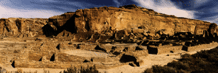
31.

panoramic view standing at the center
of the south "front" of Pueblo Bonita
(bias in this cropped image is to the left--see 33 below)
32.
panoramic view composed of the center-north &
right-east portion of the 3 views below


33
 34
35
34
35
as with the other "panoramas", 31 and 32 were
concocted/composed directly on the
scanner plate (used to create on-line copies of all the images
included herein). the
technique employed was to tape the images together on their
backsides after trying
to "line-up" the places where each edge matched the next
(obviously there is a lot
left to be desired here--one ultimate solution
would be to spring for a fisheye lens
and create single, wide-angle shots in the
first place). another shortcoming of the
current process is is the size of the scanner
bed (hp scanjet IIcx): the length of the
bed is 14 inches--but three images side-by-side add
up to more than that. hence
this long-winded explanation for cropping the
left-half of 33 in 31. another issue
in all of this is the constraint of having
the full-sized versions of these images not
exceed 768 pixels high
or 1024 pixels wide. thus the panorama shots
dwindle in
height as their length increases. but, as this
was being written, the idea presented
itself that there still needs to be a
panorama image of 33-35 that
is complete. . . .
step into part IV to
see the thumbnail of this as the first image
in the final group.
With so many images of Pueblo Bonito, it became necessary to "divee-up"
the collection in "web-manageable" chunks. Hence this artificial division:
part 0
 part I
I
part III
part VI
part I
part II
part III
part VI
Chetro Ketl
 Pueblo del Arroyo
Casa Chiquita
Kin Kletso
Casa Rinconada
Pueblo del Arroyo
Casa Chiquita
Kin Kletso
Casa Rinconada
WUPATKI
 MESA VERDE
AZTEC
CHACO CANYON
MESA VERDE
AZTEC
CHACO CANYON
tree
Index
 Search


copyright © 1995 rat haus reality press

 24.
24.


 26.
26.


